
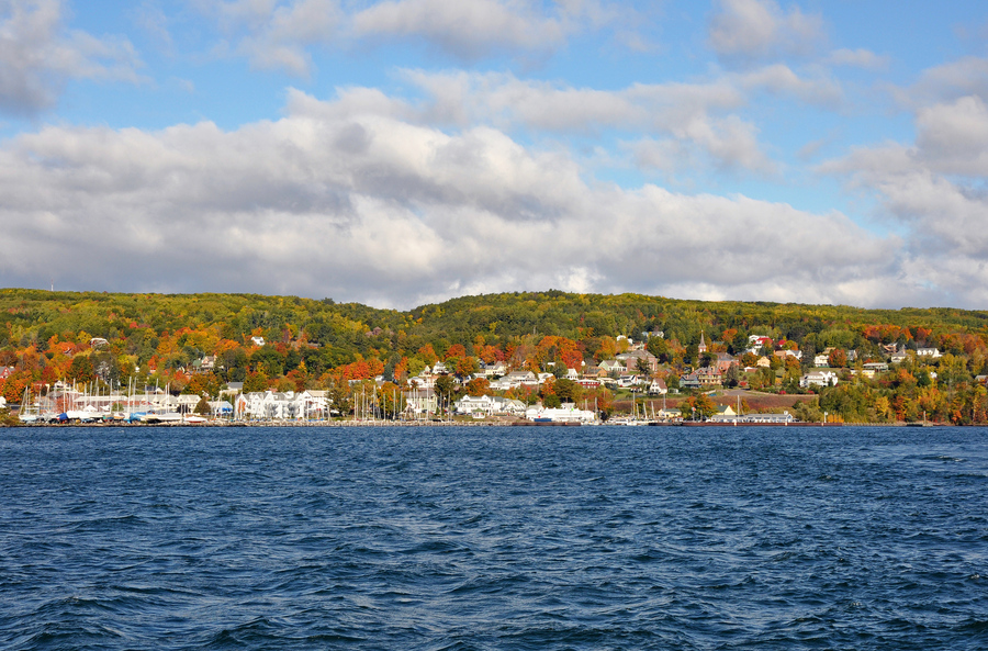
Living along Lake Superior means navigating land-use rules designed to keep the lake clean, protect wildlife habitat, and prevent structural damage from coastal erosion.
There is something deeply satisfying about looking out over the open expanse of Lake Superior, watching waves roll against the shore while crisp northern air settles around your porch.
Owning property along Lake Superior, however, involves practical responsibilities that go beyond admiring the horizon. Use this guide to help take good care of your investment and enjoy your piece of the Northwoods with peace of mind.
Table of Contents:
- What does “waterfront real estate” entail in Bayfield?
- Navigating shoreland zoning and local regulations
- Evaluating the physical shoreline, not just the views
- Assessing erosion risks and bluff stability
- Inspecting water wells and wastewater systems
- Evaluating climate readiness in the Northwoods
- The true cost of waterfront property ownership
- Access, privacy, and everyday practicality in Bayfield
- Working with professionals who know waterfront land
- FAQs about Bayfield County waterfront real estate
- Find your Lake Superior home with Broad Street Brokers
What does “waterfront real estate” entail in Bayfield?
When exploring waterfront real estate in Bayfield County, it is easy to focus on panoramic views across Chequamegon Bay or the Apostle Islands. Yet the specific legal description attached to a deed determines how you actually use, access, and maintain the property day after day.
| Waterfront property types | ||
|---|---|---|
| Direct riparian | Deeded easement | Shared outlot |
| Title extends to ordinary high-water mark; private use and permit rights. | Inland parcel with legal right to walk down a designated trail. | Common lot owned by HOA; shared beach access. |
Deeded shoreline ownership vs. shared access
Not every home listed near the lake includes direct waterfront ownership. Some properties feature full riparian ownership down to the ordinary high-water mark. Others provide access through deeded walking easements across neighboring lots or shared neighborhood paths.
- Direct riparian ownership: Gives you exclusive private use of your shoreline frontage, subject to state public trust doctrines.
- Deeded access easements: Allow you to walk to the water along a specific pathway, but you cannot build stairs, place a dock, or clear vegetation on that shared land.
- HOA or common outlots: Provide shared waterfront enjoyment among neighborhood owners, with maintenance responsibilities split among members.
Asking your agent to verify these details early prevents misunderstandings down the road.
Riparian rights come with stewardship responsibilities
Owning direct shoreline grants you riparian rights, such as placing a seasonal dock or launching kayaks. At the same time, it places you in charge of caring for a dynamic coastal environment.
Lake Superior experiences changing water levels, winter ice pushes, and strong northeast winds. Property owners must manage runoff, preserve soil stability, and protect sensitive coastal habitats.
Review essential legal documents early
Before putting together an offer Lake Superior homes for sale in Wisconsin, request and review foundational property documents:
- A professional boundary survey showing the ordinary high-water mark and exact lot lines.
- Preliminary title reports listing recorded easements, driveway agreements, or utility corridors.
- Restrictive covenants or township rules that govern property usage, accessory structures, or rental activities.
Navigating shoreland zoning and local regulations
Living along Lake Superior means navigating land-use rules designed to keep the lake clean, protect wildlife habitat, and prevent structural damage from coastal erosion. Understanding these frameworks early helps you plan future projects with confidence.
How does shoreland zoning work in Bayfield County?
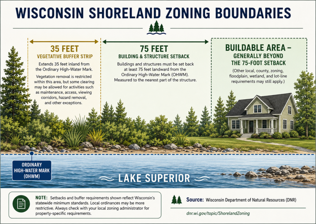
When purchasing waterfront property in Bayfield, WI, you interact directly with county zoning ordinances alongside state standards. Under shoreland zoning in Wisconsin, regulations cover land located within 1,000 feet of a navigable lake or 300 feet of a navigable river.
These rules establish baseline standards for:
- Building setbacks: Houses must sit at least 75 feet from the ordinary high-water mark, though bluff recession rules often require extra distance. In some areas subject to more severe erosion, the setback may even be up to 125 feet or more.
- Impervious surface limits: Driveways, rooftops, and concrete patios are capped at a set percentage of the lot size to prevent heavy stormwater runoff.
- Accessory buildings: Garages, storage sheds, and guest spaces must fit strictly within designated building envelopes.

Protecting shoreline buffer zones
To preserve natural scenery and prevent soil runoff, local ordinances restrict clearing native plants near the water. Within 35 feet of the ordinary high-water mark, property owners are expected to keep a healthy vegetative buffer.
While you can clear a designated viewing and walking corridor to reach the shoreline, clear-cutting trees or converting native shoreline into mowed grass is restricted. Keeping native pine, birch, and dogwood roots intact helps hold shoreline soil together during heavy rains.
Permitting existing docks, stairways, and structures
If a listing features a long wooden staircase down a high bluff or a permanent dock along the water, do not assume it was built with modern permits.
Older structures may be legally non-conforming, meaning they can remain as they are. But expanding or rebuilding them requires strict county and Department of Natural Resources (DNR) reviews.
Verifying permit histories with the Bayfield County Zoning Office protects you from unexpected removal orders or fines later on.
💡 Local rules matter!
Wisconsin establishes statewide minimums, while counties and municipalities administer the applicable ordinances. Some local requirements may be different or additional. To be sure, check with the proper Bayfield County channels.
Evaluating the physical shoreline, not just the views
The physical shoreline right outside your door shapes your daily routines, from how easily you can launch a canoe to how much ongoing maintenance the ground demands.
What are the different coastal shoreline types in the Bayfield Peninsula?
Along the Bayfield Peninsula, the coast changes remarkably from one mile to the next.

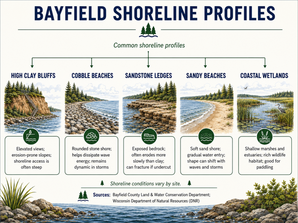
- High red clay bluffs: Elevated bluff sites near Washburn and Bark Bay offer dramatic views across open water. Because these slopes can sit high above the lake, reaching the shore sometimes requires sturdy, well-engineered stairs. Surface water runoff must also be managed carefully.
- Cobble and gravel beaches: Made of smooth stones shaped by wave action, cobble shorelines can dissipate some wave energy as stones shift and water moves through the beach. During storms and changing lake levels, cobble shorelines can also erode or migrate.
- Brownstone and sandstone ledges: Found near Houghton Point and around the northern tip of the peninsula, these solid rock ledges provide strong, permanent foundations that resist erosion and give direct access to deep water.
- Sandy beaches and coastal sandpits: Located along protected bays and near communities like Cornucopia and Port Wing, sandy shorelines offer smooth swimming access and simple kayak launches. However, sand shifting occurs naturally with seasonal lake-level changes and winter ice.
- Coastal wetlands and estuaries: Found where cold-water streams enter the big lake, these low-elevation coastal marshlands provide rich wildlife habitats and calm waters for paddling. Building near these estuaries involves strict DNR wetland protections and specialized dock permitting.
Selecting the right shoreline depends on how you plan to spend your time by the water, how you wish to access the shoreline, and the level of ongoing stewardship you want to undertake.
Microclimates and wave exposure
Lake Superior creates its own local weather patterns. Properties directly facing open water absorb the full impact of easterly and northeasterly storm winds, bringing heavy wave action and cool spring fog.
Meanwhile, properties situated inside protected coves or bays experience calmer water and warmer afternoon breezes.
Assessing erosion risks and bluff stability
Living beside Lake Superior involves respecting a shoreline that is constantly shaped by water, weather, and seasonal freeze-thaw cycles. Evaluating ground stability before closing on Bayfield County waterfront real estate ensures your home sits on solid footing for decades to come.
| Signs of Active Bluff Creep | ||
|---|---|---|
| Exposed Roots | Pistol-butt Trees | Surface Cracks |
| Soil washing away from tree bases on slopes. | Curved trunks adjusting to sliding ground. | Cracks forming along the top lawn edge of bluffs. |
What are the visual indicators of ground movement?
When touring a shoreline property, keep an eye out for natural signs that indicate active soil creep:
- Trees with trunks that curve upward near the base, showing they adjusted as the soil slowly moved beneath them.
- Patches of exposed red clay or slumping soil sections along steep bank edges.
- Deep rain gullies forming where lawn runoff flows unchecked over the edge of a bluff.
Groundwater and slope hydrology
Bluff erosion in northern Wisconsin is often caused as much by water inside the ground as by lake waves at the bottom.
Heavy red clay soils hold moisture, creating water pressure when saturated after spring snowmelt or heavy autumn rains. Keeping roof downspouts away from bluff edges, maintaining deep-rooted native vegetation, and avoiding heavy lawn watering help keep slopes stable.
Evaluating shoreline legacy protections
If a property includes rock riprap, stone revetments, or timber retaining walls along the water, look at them closely:
- Ensure wave action hasn’t scooped out soil behind or under the stones.
- Ask the seller for original permit documents to confirm the work was completed in compliance with DNR standards.
- Remember that installing new shoreline armor requires specialized coastal engineering and state permits.
💡 Here’s some neighborly advice
If you are looking at an elevated bluff property, bring in a coastal or geotechnical engineer alongside your standard home inspector. They can measure historical shoreline changes and help you feel completely confident in your foundation’s placement.
Inspecting water wells and wastewater systems
Homes located outside municipal town centers rely on private water wells and on-site septic systems. Making sure these essential utilities are in great shape is one of the most practical steps in your buying journey.

Testing private wells in Northern Wisconsin
When reviewing homes for sale in Wisconsin along Lake Superior, perform a thorough check of the private well system:
- Water quality testing: Take water samples to test for coliform bacteria, nitrates, arsenic, and mineral content like iron or manganese.
- System mechanics: Check the age of the subterranean pump, inspect the pressure tank inside the home, and verify flow rate (gallons per minute).
- Freeze lines: Ensure well supply lines sit well below the local frost line (typically 5 to 6 feet deep) to keep water flowing smoothly all winter long.
Navigating septic systems in heavy red clay soils
Because red clay soils drained slowly across parts of Bayfield County, traditional gravity drainfields are not always feasible. Many waterfront homes use engineered mound systems, pressure-distribution systems, or sealed holding tanks.
| Septic System Type | Ideal Soil Profile | Maintenance Requirements |
|---|---|---|
| Conventional Gravity | Deep, well-draining sandy loam | Standard inspection and pumping every 3 years. |
| Engineered Mound | Heavy red clay or shallow bedrock | Requires electric pump maintenance and regular inspection. |
| Holding Tank | Tight clay soils or small lot sizes | Demands regular pumping based on household water use. |
Always request recent inspection reports and pumping logs recorded with the Bayfield County Planning and Zoning Department. If you plan to expand a modest cabin into a larger, year-round residence, confirm that the current septic setup has sufficient capacity for added bedrooms.
Evaluating climate readiness in the Northwoods
When you live near Lake Superior, you also have to embrace true Northwood winters. A well-built coastal home keeps you cozy during subzero storms while keeping utility bills predictable.
| Northwoods Home Resilience | ||
|---|---|---|
| Exterior Shell | Roof Structure | Heating & Power |
| Wind-resistant siding and flashing handle lake spray. | Engineered snow loads; attic vents prevent ice dams. | Primary heat plus backup generator for winter freezes. |
Weatherproofing against lake winds and spray
Exposure to open water brings continuous wind and high humidity. Examine exterior materials for durability:
- Siding choices: Fiber cement board, natural cedar, and heavy-gauge metal siding stand up remarkably well to damp coastal air and wind-driven rain.
- Window performance: Look for double or triple-pane glass with strong weather-stripping to block winter drafts.
- Foundation insulation: Check that foundation walls, crawl spaces, and exposed floor structures are insulated properly to prevent heat loss and protect interior plumbing.
Roof snow loads and ice dam prevention
Bayfield County can see over 100 inches of snow in a single winter due to lake-effect weather. Roof structures must handle heavy snow accumulation effortlessly:
- Inspect attic insulation levels and ventilation systems. Proper ventilation keeps roof surfaces cold, preventing snow from melting and refreezing into destructive ice dams at the eaves.
- Check roof pitches and overhand designs to see where sliding snow lands, ensuring walkways and entryways stay clear and safe.
Heating systems and back-up power options
A comfortable Northwoods home relies on a reliable heating setup:
- Verify the condition of the primary heat source, whether it’s forced-air propane, hydronic in-floor radiant heat, or high-efficiency wood stoves.
- Consider installing or verifying a stand-by generation. During severe winter ice storms, a generator keeps furnace blowers running and prevents water lines from freezing if utility power drops out.
The true cost of waterfront property ownership
Investing in a waterfront property in Bayfield County, WI is an ongoing commitment to property care. Budgeting for ongoing operational expenses early ensures your Northwoods experience stays enjoyable and stress-free.
Specialized coastal insurance needs
Standard homeowner policies do not always cover every coastal environmental hazard. Talk with a local insurance agent to review the following:
- Windstorm and hail coverage adjustments for properties right along the water.
- Specialized flood endorsements if structures sit near lower coastal flats or river outlets.
- Seasonal occupancy rules if the house sits vacant during winter months.
Private roads, driveways, and mud season
Many shoreline homes sit along private gravel roads or long wooded driveways. Factor in the routine maintenance required:
- Arranging seasonal snowplowing contracts so emergency vehicles and family cars can get in and out all winter long.
- Adding gravel and grading long driveways after the spring mud season.
- Sharing road maintenance expenses with neighbors along private road associations.
Wooded lot care and storm cleanup
Wooded lots provide wonderful privacy and shade. But mature trees near coastal waters require regular maintenance.
High winds off Lake Superior can down limbs or weaken older trees. Partnering with a local arborist to trim hazardous branches keeps your roof, power lines, and views clear.
Access, privacy, and everyday practicality in Bayfield
Your waterfront property should feel welcoming and easy to live in throughout every month of the year.
Navigating northern seasons
A home that feels ideal on a warm July afternoon needs to remain practical during a snowy February weekend.
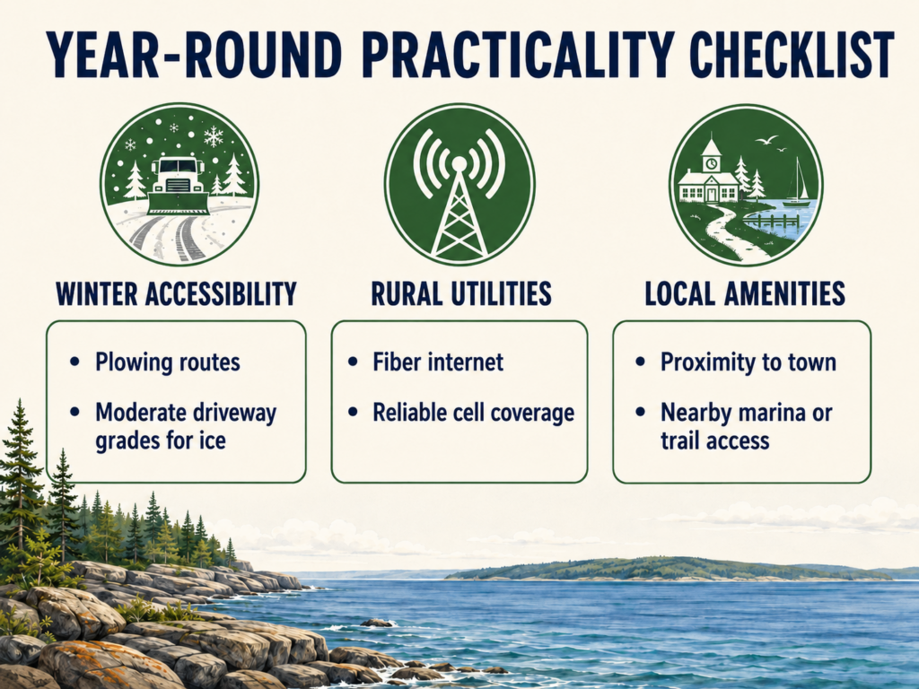
- Check the slope of the driveway to make sure vehicles can navigate it when covered in winter-packed snow or ice.
- Confirm cell phone signal strength across the parcel and verify high-speed fiber internet availability if you plan to work remotely.
- Identify the nearest year-round grocery stores, clinics, and hardware shops in towns like Bayfield, Washburn, or Iron River.
Balancing seclusion with neighborhood connection
Whether you are looking for quiet woods where the only sound is wind through hemlocks, or a home within walking distance of local bakeries and harbor marinas, Bayfield County offers distinct communities.
Checking local public trails, boat launches, and seasonal traffic flows helps you find the exact balance of privacy and community you want.
Working with professionals who know waterfront land
By now, you know: buying waterfront real estate in Bayfield County involves specific technical details that standard real estate transactions rarely touch. Assembling a knowledgeable local team ensures every detail is handled correctly.
Your support team should include:
- Regional real estate specialists: Local brokers who understand township ordinances, short-term rental rules, and local shoreline dynamics.
- Licensed Wisconsin land surveyors: Experts who map official boundaries, ordinary high-water marks, and setback contours.
- Master plumbers and septic inspectors: Licensed professionals who verify well water safety and soil absorption systems.
- Geotechnical consultants: Coastal engineers who assess bluff stability and design long-term stabilization plans.
Having local experts in your corner lets you make informed decisions with local clarity.
FAQs about Bayfield County waterfront real estate
What is the standard building setback for Lake Superior shoreline in Bayfield County?
Wisconsin shoreland zoning requires homes to sit back at least 75 feet from the water. However, coastal bluffs and active erosion areas often require greater distances for safety.
Can I clear trees and plants along my shoreline to open up my lake view?
Not completely. State law protects a 35-foot vegetative buffer from the water. You may trim branches and open a narrow viewing path, but clear-cutting is strictly restricted.
What kind of septic system do I need for a Bayfield County waterfront property?
Because local red clay drains slowly, traditional drainfields often fail. Most properties require sealed holding tanks or engineered mound systems, determined by soil tests.
Find your Lake Superior home with Broad Street Brokers
The team at Broad Street Brokers brings over 40 years of combined experience, deep regional roots, and friendly Northwoods hospitality to every transaction. Ready to explore your shoreline options along the peninsula?
Call our office at 715.779.3220 or send us a message to get your comprehensive real estate consultation.